Monday, April 2, 2012

Look back at March 2012

As I noted in previous posts, March 2012 was incredibly warm across the central and eastern U.S.  Now that the dust has settled, we can take a look back at what might have caused this early spring heatwave and just how infrequent such an event is.  The NOAA Earth System Research Laboratory released a preliminary analysis of the episode.  Here are the highlights:
  • Over 7000 daily record highs were set across the country
  • Anomalously strong and persistent southerly flow transported warm air poleward from the Gulf of Mexico into central Canada
  • Warming was intense throughout the troposphere, indicative of deep layer meridional transport
  • Lack of snow cover was likely not a major factor, except perhaps the northern Upper Midwest
  • Signals of the upcoming heat wave were detectable well in advance of the event
  • Global warming associated with greenhouse gas (GHG) emissions contributed ~ 5 to 10% of the intensity of the heat wave (preliminary estimate)
This last bullet is perhaps most interesting.  Assessing the influence of global warming on individual weather events is quite difficult, and since global warming came to the forefront of the atmospheric sciences, I have seen few weather events described as, in part, enhanced by global warming.  As the NOAA analysis points out, it's highly unlikely that warming due to GHG emissions caused the heat wave, but it is quite likely that it enhanced the magnitude of the event.  Studies also show that warming associated with GHG emissions  does increase the chance that extreme weather events, such as heat waves, will occur, and perhaps enhance them when they do occur.  Climate researchers often use an analogy of "loading the dice" to describe this.  The take home message:  The March heat wave was extraordinarily rare, but these types of events may occur more frequently as uncontrolled GHG emissions continue.

Back here on the West Coast, we finally had a month with above-normal rainfall in San Francisco.  The downtown observation site reported 5.71" of rain in March, which was 2.45" above normal.  We're still way below normal for the season though.  The Northwest has been extremely wet this March, with Portland and Spokane recording their wettest March on record.  Coming up, we have a decent chance for at least light rain in San Francisco on Tuesday night, followed by a warm up into the weekend.

Monday, March 19, 2012

Unprecedented warmth in the Midwest


The Midwest/Great Lakes region continues to bask in historic warmth for the middle of March.  Temperatures have been in the 70s and 80s across a wide area from Missouri to Minnesota and east to the Mid-Atlantic.  The culprit is a highly amplified upper-level pattern over the country.  A strong ridge has persisted and strengthened from the Southeast northward to Ontario, with a deep trough over the Rockies.  That trough brought us all the rain last week and snow into Arizona and northern Mexico.  Also of note is the wind flow from Texas due north to central Canada.

Just how warm has it been?  Numerous locations are on track for their warmest March on record.  The graph on the right is from the Chicago National Weather Service office, showing the average March temperature and the previous 4 warmest Marches on record.  2012 is on pace to blow away the old record.  Tomorrow's forecast high for Chicago is 85º - this is warmer than Chicago's average high in the middle of July.  This is indeed a historic event, and as such, it's difficult to predict what's coming next.  Much of weather forecasting is based on a phenomenology of what's happened in the past, but we don't really have much to compare these warm temperatures to.  While good for outdoor spring/summer activities, this unusual warmth could have implications on things like crops and lake water levels.

As for California, last week's series of systems brought us much needed rain, with over 10 inches falling in some of the higher elevations of the Bay Area.  For San Francisco, we're up to about 50% of normal for rainy season precipitation.  And, the Sierra received several feet of snow.

Tuesday, March 13, 2012

Rain moving through; very warm Midwest/East

The first storm system in a series is moving through the Bay Area right now.  It brought light to moderate rain for much of the region with rainfall totals from near a half inch in San Francisco to over two inches in the North Bay, with generally a quarter inch or less south of SF.  These totals are a bit less than was forecasted but still respectable.  The latest radar image shows just a few light areas of rain slowly shifting southward across the area with the bulk of the rain remaining over far northern California.

One area of note though was the South Bay.  San Jose still has only reported a trace of rain from this system, despite radar imagery showing rain over the region for much of the day (not at present though).  A likely reason for this was strong southerly winds for much of the day.  Southerly flow enhances rain in parts of the North Bay mountains and the southward facing Santa Cruz mountains.  However, San Jose is north of the Santa Cruz mountains, so San Jose may have been in the rain shadow.  I haven't looked at enough data to support this hypothesis, but it is possible.  Also, the San Francisco/Monterey area radar is located on Mount Ununhum in the Santa Cruz mountains at near 3000 feet elevation, and thus is detecting rain/clouds well above sea-level.  So while it may have shown rain over the South Bay for much of the day, that precipitation was likely well above the surface and not reaching the ground.

We have a weaker system coming in Thursday afternoon and then a stronger, colder system for Friday and Saturday.  That one will bring much lower snow levels and still some possibility for a few thunderstorms. 

Meanwhile, unseasonably warm temperatures will cover much of the Midwest and East this week, with highs well into the 70s and even 80s.  These temperatures are extraordinarily warm for mid-March, over 30 degrees above normal in some spots.  Chicago, as an example, is expecting highs in the low 80s for Wednesday, which is more typical of June.  The average high for Wednesday is only 46º.  This will certainly be a new daily record, but this may go down as one of the warmest March weeks on record for many locations.  The table below shows a few cities and forecast highs for Wednesday.

Sunday, March 11, 2012

Wet week ahead for Bay Area

After a fairly average weekend in the Bay Area, with periods of sun, clouds, drizzle, and onshore winds, we have a much more active weather pattern in store this week.  As I alluded to in earlier blogs, several signs were pointing to a wet period in mid-March, and it's about to start.  In fact, this may very well be the wettest week of the winter season.  Very moist air from the subtropics is moving northeastward across the eastern Pacific, currently headed for the Pacific Northwest associated with a strong upper-level trough developing off the coast.  This system brought thunderstorms, heavy rain, and large hail to Hawaii a few days ago.  This trough will gradually sink southeastward across California this week bringing periods of rain, sometimes heavy.  Rain will begin in the Bay Area on Monday night as a warm front moves through.  As warm air moves in from the southwest, it is forced up and over cooler air at the surface.  This results in clouds and precipitation.  Rain will generally be light to moderate into early Tuesday before a strong cold front moves in with a period of heavy rain and wind late Tuesday.  The first image is a model 12-hour precipitation forecast for the day Tuesday, indicating at least an inch of rainfall for much of the area.  The other computer models are in agreement as well, which gives us more confidence in the forecast.  Another cold front will drive through Thursday into Friday with more rain.

The parent upper-level trough will then settle over California this weekend as indicated by the second image.  This will bring in much colder air, especially aloft, and will result in very low snow levels - perhaps lower than 2000 feet at times.  With such cold air aloft, combined with the relatively strong March sun, the atmosphere will become quite unstable (by California standards).  This may result in a few thunderstorms in the Bay Area, but it's still too early to say for sure.  Regardless, we can expected perhaps 2 to 4 inches of rain in the Bay Area this week with several feet of snow in the Sierra.  This is very good news considering the lack of rain so far this winter!

Also on the weekend forecast map, notice the strong upper-level ridge over the eastern United States.  Many locations there, even the northern states, may have temperatures in the 70s.  That would be extraordinarily warm for this time of year, considering that often such locations (Great Lakes and the Northeast) are covered with snow in early to mid-March.  It is not uncommon though to have one side of the country cool and wet while the other is unseasonably warm.  In fact, this is often the case.  Strong troughing over the western U.S. forces strong, downstream ridging over the eastern U.S. in response, and vice versa.  This is why it may often seem that during periods of sun and warmth here, the Midwest and East are getting severe thunderstorms and/or snowstorms.

Sunday, March 4, 2012

More Midwest/East tornadoes

Friday, March 2, 2012 will long be remembered in the Ohio Valley for its outbreak of severe thunderstorms and tornadoes.  Dozens of tornadoes were reported across a large area from Indiana southward to Alabama, some large, and resulting in about 40 fatalities.  A particularly strong, long-tracked tornado carved a long path across southern Indiana into far northern Kentucky, narrowly missing Cincinnati.  The image on the right is a compilation of large hail, damaging wind, and tornado reports from March 2.

This event was a classic setup for severe weather.  A low-pressure system rapidly developed over Missouri and accelerated northeastward toward Michigan.  Ahead of this system, warm, moist air from the south surged northward.  And, a strong jet stream aloft resulted in strong vertical shear - that is, winds changing in speed and direction with height above the ground.  This is an essential ingredient for tornadoes.  And, much colder air rushed in behind this system.  Heavy, wet snow blanketed the region from Chicago and Milwaukee and eastward across Michigan.  I'll talk more details about the meteorological factors behind severe thunderstorms as the spring continues.

Conversely, we have had continued benign weather here in the Bay Area.  Temperatures were well above normal this weekend, with highs in the 70s and even a few 80s well inland.  This will quickly change Monday and Tuesday as a cold front moves through.  Precipitation will be light, but it will become quite windy, especially on Tuesday.  Thursday, Friday, and possibly Saturday look nice though.  After that, indications are still there that the middle of March could be wetter than normal across northern and central California.  This is still a long way out in terms of reliable forecasting, but it would be welcome precipitation after a very dry winter.

Wednesday, February 29, 2012

Heavy Sierra Snow, Tornadoes East

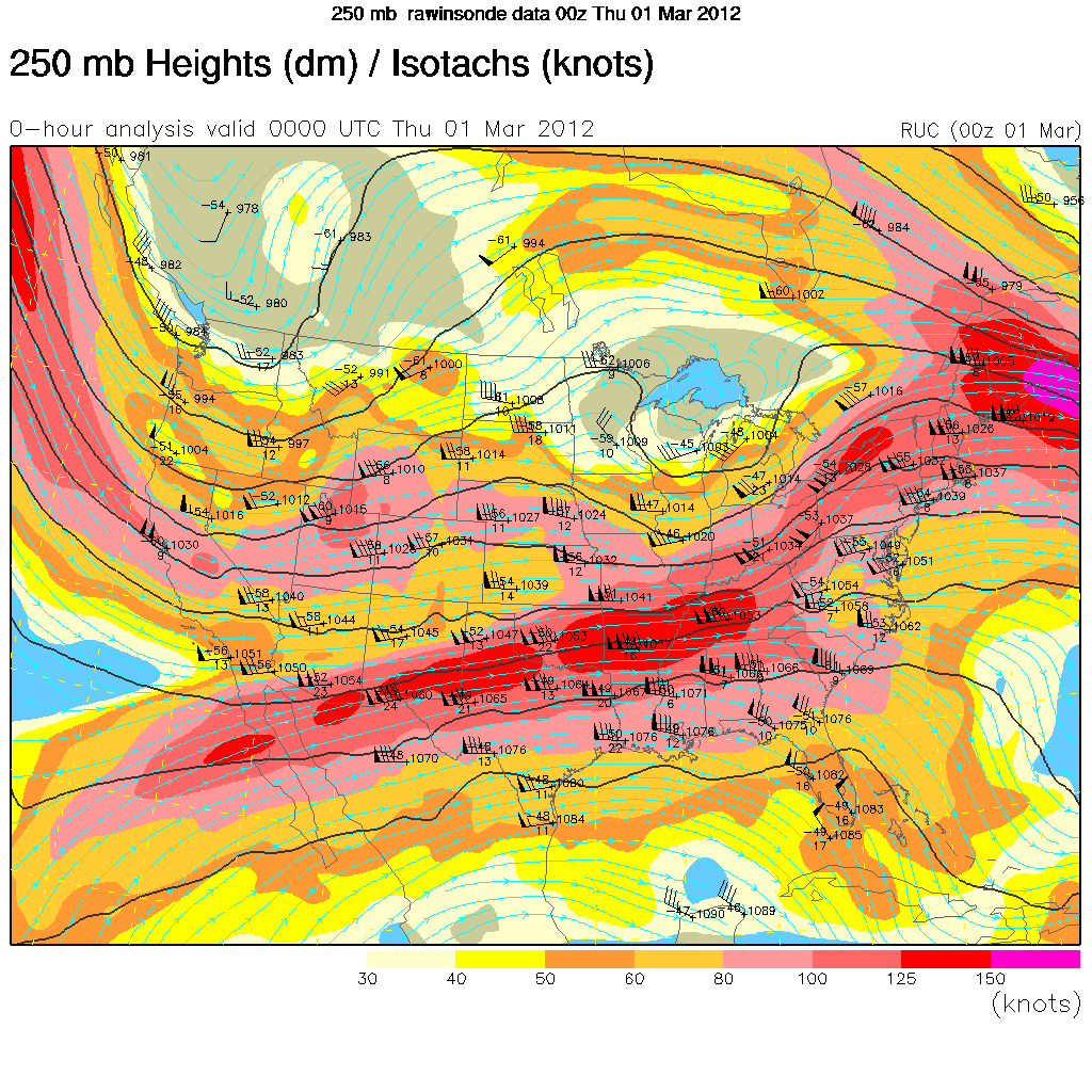
In my previous post, I talked about the dearth of snow in the Sierra.  In timely fashion, a strong storm system is bringing heavy snow to the Sierra, with several feet of accumulation expected.  This is a cold, moist storm that originated over the Gulf of Alaska.  While not a big rain producer at lower elevations (only a quarter to half inch in the Bay Area), the dynamics and moisture profile associated with this system favors heavy snow in the Sierra.  As the system moved in, strong, moist west-northwesterly mid- and upper-level winds impinged on the Sierra.  This is evident in the map on the right, which shows wind up around 30,000 feet.  As this flow hit the Sierra, it was forced to rise and inevitably cools.  As the air cools, it is unable to hold as much moisture, so that moisture condenses out in the form of clouds and snow.  This also favors the heaviest snow on the western slopes of the Sierra up to the crest, with less snow on the eastern side.  Snow levels will be as low as 2000-3000 feet, with snow accumulations up to 5 feet for locations above 7000 feet elevation.  The snow will continue on and off through Thursday before a warmer, drier air mass moves in this weekend.  The copious snow will improve the water outlook picture somewhat as we head into the spring.  And, I think there are still signs of a more active weather pattern for northern California around mid-March.

Meanwhile, on the same upper-level wind map above, there is a strong jet stream over the southern United States.  This is associated with another storm system that produced severe thunderstorms with tornadoes across parts of the Mississippi Valley.  Unfortunately, many of the tornadoes occurred overnight and early this morning.  This is extremely dangerous since most people are sleeping without any idea a tornado is approaching, and since it is dark, tornadoes are difficult to see and track.  One tornado that moved across southern Illinois, causing several fatalities, has already been rated EF-4 (on a scale of 0 to 5), with winds of 175 mph.  It is not unusual to have tornadoes in late February, but this time of year they are more common across the Deep South as opposed to Missouri and Illinois.

Thursday, February 23, 2012

Dry winter continues

Our very dry winter continues in northern California.  Sounding like a broken record now, a strong ridge of high pressure remains quasi-stationary over the eastern Pacific into California, keeping us in dry northerly flow.  Storm systems have continued to track from the Pacific Northwest southeastward into the Great Basin, but have mostly stayed to our northeast.  And, these systems are not big rainmakers anyway, as they are coming from a northerly (dry and cold) trajectory instead of a more favorable west or southwesterly trajectory (moist and warm).


So far, San Francisco has received just 6.86 inches of rain so far this water year, or about 40% of normal.  The Sierra snowpack also remains well below normal, as shown in the first image.  Much of the west (and especially the Sierra) has below-normal snow water contents, with the exception of the northern tier states.  This is troublesome heading into the spring, because the majority of our precipitation in California falls from November through February.  If not for the precipitation surpluses of last year, we would be in considerable trouble from a water resource perspective.  The second image is the U.S. Drought Monitor, a depiction of drought status across the country updated weekly.  Most of California is in a Moderate drought, but this is likely to degrade further unless we get substantial spring storms.  Elsewhere across the country, we find comparably much worse drought conditions over Texas - much of that is carryover from 2011, which was extremely hot and dry in that area.  There are some subtle signs that we could see increased precipitation here in California in March.   Let's hope so!