Sunday, July 1, 2012

Derecho

On Friday, an intense line of thunderstorms moved across the Midwest and Mid-Atlantic, producing very strong winds and widespread damage to trees, power lines, and homes.  The storms developed in the Chicago area and tracked rapidly east-southeastward along a weak stationary front, moving across northern Indiana, much of Ohio, West Virginia, and then into Washington, DC.  The stationary front separated very hot, humid air to the south from (slightly) less hot, drier air over the Great Lakes.  The first image is storm reports from Friday, clearly showing the path of this storm.  Wind gusts between 70 and 95 mph were common along this path; several people were killed (mostly in car-related accidents with trees) and millions were without power.  Long-lived thunderstorm complexes producing straight line winds are called derechos.  These systems are not uncommon in the summer months, usually over the northern United States or southern Canada.  This one was particularly notable though for its track through heavily populated areas, and that it cut power to millions during an intense heat wave.

The second picture is a series of radar images as the derecho moved across Indiana and Ohio.  Note how over time, the line of storms expands and takes on a arc-like shape.  The strongest winds are usually found near the center, or apex, of the bow.  Some weather and media sources have started referring to this system as a 'land hurricane', because wind gusts were equivalent to minimal hurricane strength.  Really though, the term 'land hurricane' is inappropriate for this system.  This name only serves to confuse the general public and implies that Friday's event was a new phenomenon that has not occurred before.  Hurricanes are large, slow moving systems that feed off warm ocean waters.  Hurricanes do not form, and are not associated with, frontal boundaries.  The derecho that occurred on Friday was extremely fast (moving at 75+ mph) and developed along a stationary front, the interface between two dissimilar air masses.  Clearly, the comparison is bad at best.

Tuesday, June 26, 2012

Unusual warmth continues for central U.S.

After a record warm spring across much of the central, southern, and Mid-Atlantic regions, record heat continues into early summer.  A very strong upper-level ridge of high pressure has remained the dominant feature over the central and eastern U.S., producing very warm temperatures.  This ridge has also suppressed thunderstorm activity, which is resulting in worsening drought conditions for much of that region.  Large wildfires are now burning near populated areas of Colorado, including Fort Collins, Boulder, and Colorado Springs.  Both today and yesterday, Denver tied its all-time record high temperature of 105º - to tie that record once is rare enough, but two days in a row is extremely unusual.  Later this week, temperatures are expected to climb to or exceed 100º across a wide swath of the country from Texas northward to Michigan and east to the Atlantic.  100º temps are quite rare for the northern Midwest, especially so early in the summer season.

One factor resulting in the hot temperatures is very dry ground/soil in the central U.S.  Dry ground warms and cools much faster than wet ground (and water surfaces).  However, the lack of rainfall and dry ground also results in lower humidity levels.  So, while air temperatures may be near 100º, humidity levels will not be terribly high.  This summer is showing some similarities to the summer of 1988, which was a very hot, dry season for the central U.S.

The tropics continue to be unusually active, with four names storms already occurring in the Atlantic.  Currently, Tropical Storm Debby is crossing Florida (see satellite image on right), producing very heavy rains and a few tornadoes.  The silver lining there is much of Florida was experiencing drought conditions, so Debby's rains are not entirely unwanted.  Debby will continue tracking northeastward away from Florida and across the Atlantic.

A strong upper-level trough of low pressure has been anchored along the West Coast, resulting in cooler-than-normal temps and unusually heavy rains for June in the Pacific Northwest.  This trough has helped to mix out the marine layer and fog for the past several days, so locations along the coast (like San Francisco) have had more sun recently than is typical for June.


Thursday, May 17, 2012

Eclipse Update

Just a reminder about the eclipse - will start around 5:30 p.m. on Sunday here in San Francisco and last a couple hours.  The peak of the eclipse, which in SF will mean about 80% of the sun is covered by the moon, will only last a few minutes though.  Skies will be clear inland, but there may be fog near the coast.  It would be nice to see the eclipse out over the water, but we probably know until Sunday where the fog will be.  Mount Tam in Marin might be a good spot for viewing!

Thursday, May 3, 2012

Solar Eclipse - May 20

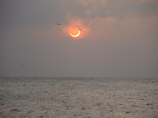
Later this month, a solar eclipse will take place, visible across the northern Pacific and the western United States.  This will be the first solar eclipse visible from the continental U.S. since 1994, showing how rare these events can be.  This particular solar eclipse is called an annual solar eclipse.  This means that at no point will the sun be totally obscured by the moon; instead, the outer edge of the sun will be visible as the moon passes in front of the sun.  This is because the moon will be relatively far from Earth, and thus appear smaller relative to the sun.  In a total solar eclipse, the entire disk of the sun is obscured by the moon, and occurs when the moon is relatively close to Earth.

The May 20 eclipse will peak along the path shown on the map (on the right), so far northern California into Nevada will see the moon directly over the sun.  The path is quite narrow, which illustrates the rarity of any one location experiencing the peak of an eclipse.  Here in San Francisco, the eclipse will start around 5:15 p.m. local time and peak around 6:30 p.m., so the sun will be low in the western sky.  At its peak, over 80% of the sun will be obscured by the moon as viewed from San Francisco - definitely not an event to miss!  Of course we also need clear skies to see this event, and often in the late evening we have fog rolling into the city.  Going just a few miles inland though should offer good viewing without fog, though.  Here's some more detailed information on the upcoming eclipse.

A total solar eclipse will occur on August 21, 2017 with a long, narrow path of totality across the United States, from Oregon southeastward all the way to South Carolina.  All of North America will see at least a partial eclipse during this event.

In the meantime, another nice weekend coming up for the Bay Area - mostly sunny with highs in the 70s near the coast and bays and 80s inland.

Tuesday, April 24, 2012

Unusual weather continues...

So far, April has brought record heat to the western U.S. with much cooler, wetter weather in the East, especially when compared to the record heat there back in March.  A strong upper-level ridge of high pressure brought sunny, warm weather to the immediate West Coast this past weekend.  San Francisco didn't break any records with highs in the 70s.  Many locations in the Central Valley, the Southwest, and the Pacific Northwest did break daily record highs over the past few days though, and some locations in the Great Basin even set new record highs for all of April.  This ridge is slowly moving east, and brought more record heat today for the Rockies and Plains.

Meanwhile, a strong trough of low pressure has been parked over the Northeast, resulting in cool temperatures and over the weekend produced heavy rain along the coast.  Over parts of western New York and Pennsylvania, heavy, wet snow fell, with over a foot in some locations.  For some parts of the Northeast, this was the biggest snowfall of this otherwise mild winter season.

Also incredible is that after the record warmth across the Midwest back in March, April is now on track to be cooler than March was.  Such an occurrence is extraordinarily rare, but will likely happen this year in Chicago, Milwaukee, and other nearby locations.  The last time this happened in Chicago was 1907.  And, this April will likely be 2º to 3º above normal for Chicago but will still be cooler than March, demonstrating how unusually warm March 2012 was.

In San Francisco, we've obviously cooled down since this weekend as a low-pressure system approaches from the Pacific.  Today was still fairly nice though, with mild temperatures and not much wind because onshore pressure gradients have weakened compared to Sunday and Monday.  As a quick measure of onshore gradients, we look at the pressure difference between San Francisco and Sacramento.  Outside of winter, SF normally has higher pressure and Sacramento has lower pressure (due to stronger heating in the Valley).  The approaching low pressure system offshore though has disrupted the usual onshore gradient, keeping the gradient almost neutral today.  So, we've had a relatively mild evening (image on right) without the usually-strong westerly winds.  Anyway, the bulk of the rain with the approaching system will be focused on southern California, but we will see some showers and possibly a thunderstorm in the Bay Area Wednesday afternoon and night.  Then, this weekend looks sunny and seasonable, with highs in the low 70s for downtown SF but cooler near the beaches with onshore flow.

Sunday, April 15, 2012

Another tornado outbreak

Yesterday, atmospheric conditions were particularly favorable for large, destructive tornadoes across the Central Plains.  In brief, the system that brought thunderstorms to San Francisco on Thursday moved across the Rockies and into the Plains yesterday, where it encountered a warm, humid air mass.  This system had a strong jet stream aloft and good directional shear - that is, winds from different directions at different heights in the atmosphere.  In this case, south and southeasterly winds at the surface brought in warm, moist air; these winds veered to the southwest and west higher aloft, and brought in much drier air.  This change in wind direction with height is a critical ingredient in supercell thunderstorms and tornadoes.  The thunderstorms with this system formed along a dryline - similar to a front, but very shallow and separates warm, humid air to the east from dry, hot air to the west.  Drylines are focal points for convergence and rising motion, making them a trigger for cloud and thunderstorm development.  The top picture is a radar image of one of the tornadic supercell thunderstorms, this one over south central Kansas.  The radar itself is located in the black dot at the top-right of the image, in Wichita (KICT).  Green indicates light precipitation; red indicates heavy (and probably large hail).  Notice the hook-like appendage at the southwest corner of the storm - the tornado is located there, south of the heavy rain and hail.  The second figure shows radar velocities at the same time.  Doppler radars have the ability to detect whether cloud/rain drops are moving toward or away from the radar.  Green/blue areas indicate motion toward the radar (toward Wichita) and red is motion away.  The figure shows a textbook velocity "couplet" with this storm - the dark green and blue area next to the red/white/purple area.  This indicated rotation and likely a tornado.  Here's a link to video of some of the tornadoes.

Several tornadoes occurred across Oklahoma, Kansas, and Nebraska.  Some of the tornadoes were quite large and long tracked; fortunately, this part of the country is sparsely populated, so injuries and fatalities were relatively low considering the number and size of these storms.  But as important was excellent forecasting by the National Weather Service (NWS) and the Storm Prediction Center (SPC).  On Friday, 24 hours before the event, SPC issued a High Risk severe weather outlook for the central Plains.  High Risks are rarely issued, and are almost never issued a day in advance.  This gave the region a good heads-up that tornadoes were likely.  Then, on Saturday during the event, the local NWS offices in the region did a great job in issuing tornado warnings.  The map on the right shows the observed tornadoes (dots) and the tornado warnings issued by NWS (red).  Most all of the tornadoes had warnings associated with them, with only a few false alarms (when warnings were issued and no tornado was reported).  Hats off to those forecasters.

Unfortunately there were five fatalities, all in Woodward, Oklahoma.  A tornado struck the town in the middle of the night and the tornado sirens weren't working - they were damaged in a thunderstorm earlier that same day.  The situation could have been much worse though, because larger population centers, like Wichita, Kansas, were also hit, but without fatalities. 

We have very benign weather for the next week in San Francisco.  There will be occasional fog especially near the coast, but otherwise mostly sunny all week with highs in the 60s and by Friday/Saturday into the 70s.

Thursday, April 12, 2012

Thunderstorms in San Francisco!

We've had quite an eventful couple of days weatherwise across California.  Yesterday, a storm system moved through with mostly light to moderate rain in the Bay Area.  Daytime heating though helped fuel several thunderstorms in the Central Valley, one of which produced a tornado near Stockton (picture on right).  The tornado was rated an F1 (on a scale of F0 to F5, F5 being the strongest) with winds estimated near 90 mph; one garage was destroyed while the tornado was briefly on the ground.  Tornadoes are rated based on the damage they produce.  Tornadoes are generally rare in California and when they do occur, they are usually weak and short lived, and occur in smaller thunderstorms compared to the large, supercell thunderstorms that produce violent tornadoes east of the Rockies.  I'll write more about that in a future post.

Then, last night, another system quickly moved through with a brief period of heavy rain, gusty winds, and a few lightning strikes in the San Francisco area.  A stronger system is now impacting our region and produced a strong line of thunderstorms that crossed through San Francisco earlier this evening.  Those storms produced a lot of lightning and thunder - probably the most I've seen in my ~6 years on the West Coast.  It wasn't quite a Midwestern thunderstorm, but it was quite impressive for San Francisco.  Rain will continue on and off tonight into tomorrow morning.  Then, Saturday will be partly sunny but cool, followed by warmer temps Sunday and Monday.